
Z-Axis (Height Above Terrain)
Product: Prepared
Audience: Call Takers, Dispatcher, Supervisors
Last Updated: 03/04/2025
Outcome Statement
After reading this section, you will understand how to use the Prepared Z-Axis feature to access real-time vertical location data (floor level) and improve emergency response accuracy in multi-story structures.
Overview
The Prepared Z-Axis feature, powered by NextNav, provides precise floor-level location data to 911 dispatchers and responders, allowing them to pinpoint the exact location of an emergency within a multi-story building. This capability helps save valuable time by eliminating the need to search for the caller's exact location. The Z-Axis feature complies with FCC requirements for "floor level" accuracy, offering reliable vertical location information in high-rise or multi-story environments.
Prerequisites
✅ NextNav service availability in your area (check the coverage map).
Step-by-Step Instructions
Access Z-Axis Data
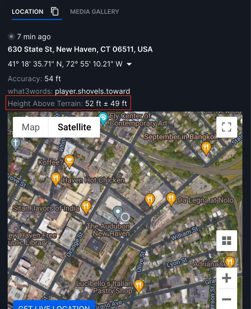
From the dispatcher interface, navigate to the caller’s location information.
The Z-Axis data will appear in the location section as "Height Above Terrain."
Interpret Z-Axis Data
The Z-Axis data shows the caller's vertical location (floor level).
An error margin will also be displayed (e.g., +/- X feet). Dispatchers should consider this when estimating the exact floor level.
Share Z-Axis Information
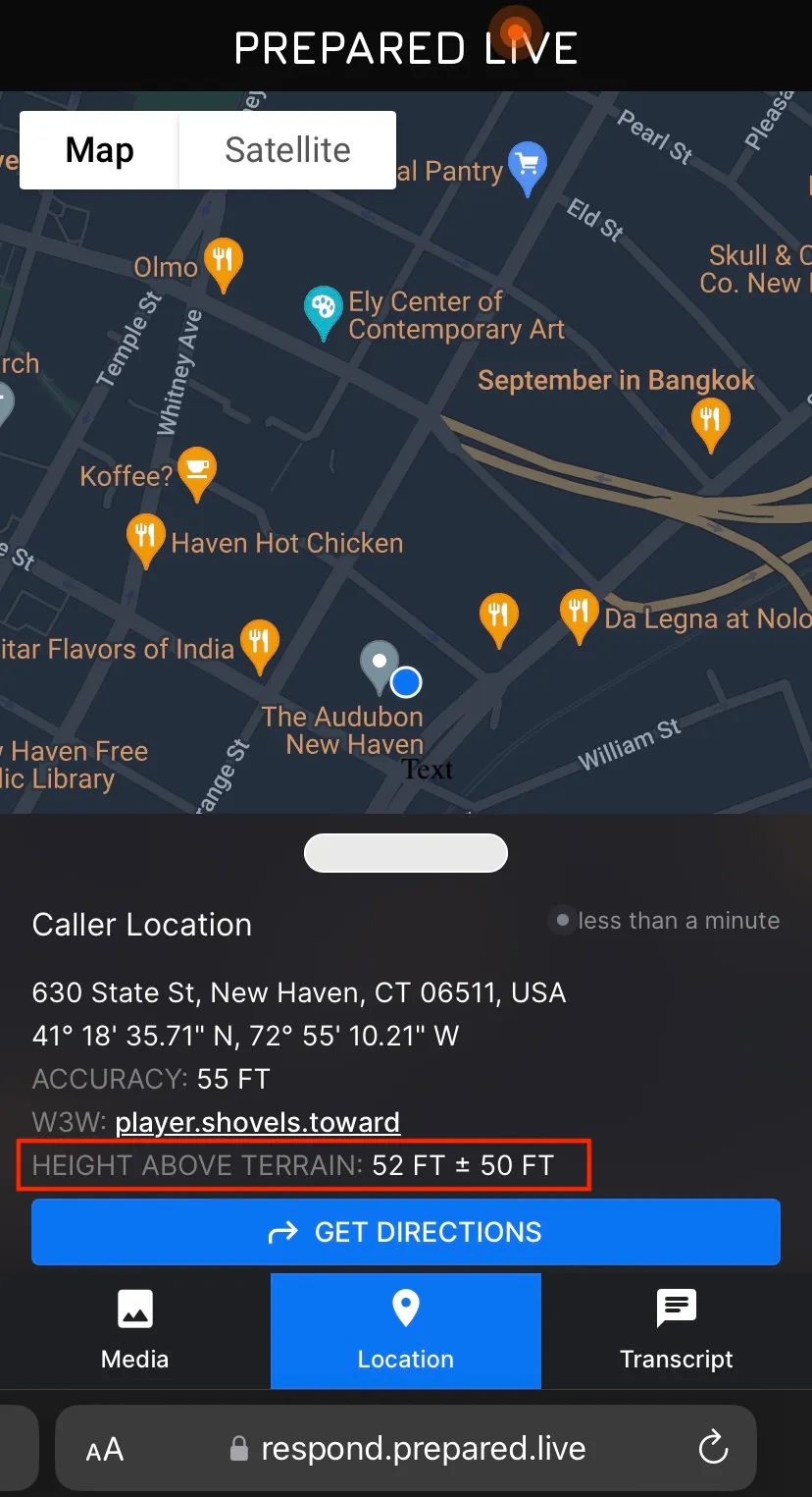
Forward the Z-Axis data to responders by sending the Prepared link.
Responders will receive the data on their mobile browser client or through the MDT app.
Be sure responders understand the error margin and its effect on the vertical location estimate.
Verify Coverage
Use the NextNav Coverage Map to ensure that the area where the emergency is taking place is covered by the service.
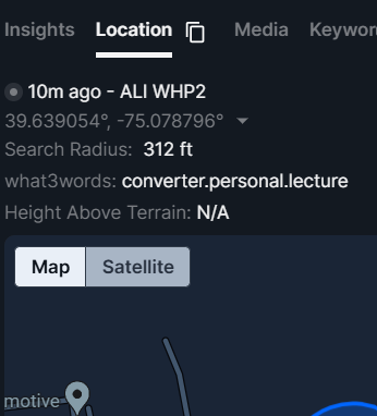
If services are not available in your area it will be displayed as follows
Best Practices
Use Z-Axis data to confirm the caller’s floor level, particularly in high-rise or multi-story buildings.
Always factor in the error margin when using Z-Axis data to ensure the most accurate response.
Check the coverage map to verify service availability in your region before relying on the feature.
FAQs
Question | Answer |
|---|---|
Can dispatchers see the caller's floor level in all locations? | No, Z-Axis data is only available in areas covered by NextNav’s Pinnacle service. Verify coverage with the coverage map. |
Do responders need any special equipment to view Z-Axis data? | No, responders can view Z-Axis data via the Prepared link on their mobile browser or the MDT app. |
How accurate is the Z-Axis data? | The accuracy of the Z-Axis data is generally within +/- 3 meters. Be sure to consider the displayed error margin when interpreting the data. |
Can Z-Axis data be used in all buildings? | No, the Z-Axis feature is most useful in multi-story buildings. It is not relevant for single-story locations. |
Appendix
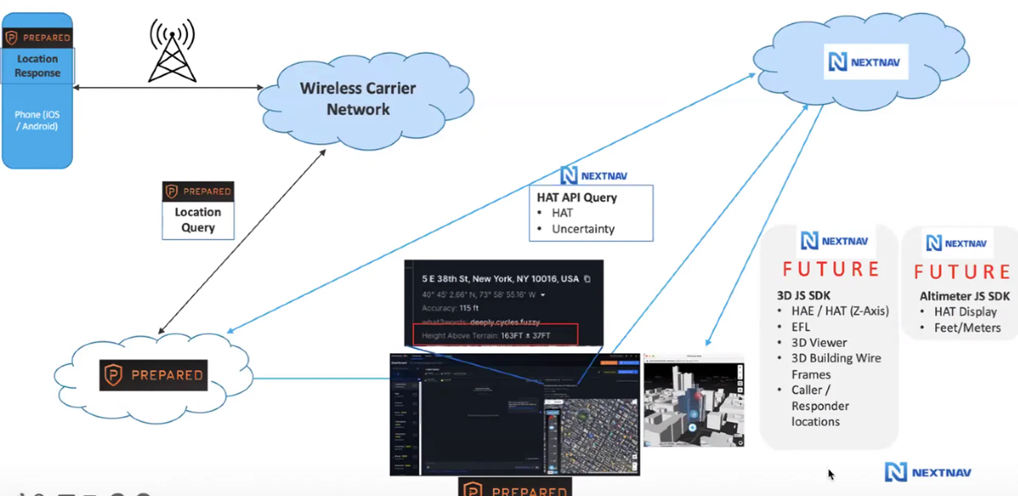
How Does the Prepared + NextNav Integration Work in the Backend?
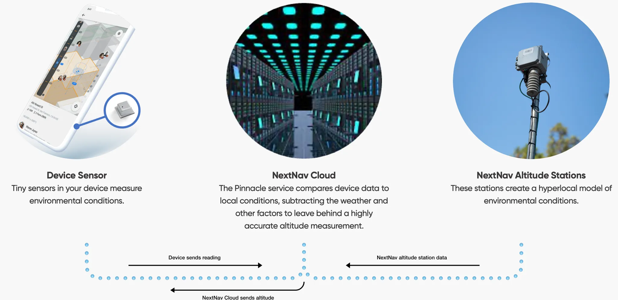
The integration leverages barometric sensors in mobile devices and tablets to calculate the vertical location of a caller.
This data is then passed to the Prepared system for display and sharing with responders.
The system includes real-time error margins to ensure precision and guide responders in interpreting the location data.
What is
Height Above Ellipsoid (HAE) and Height Above Terrain (HAT)?
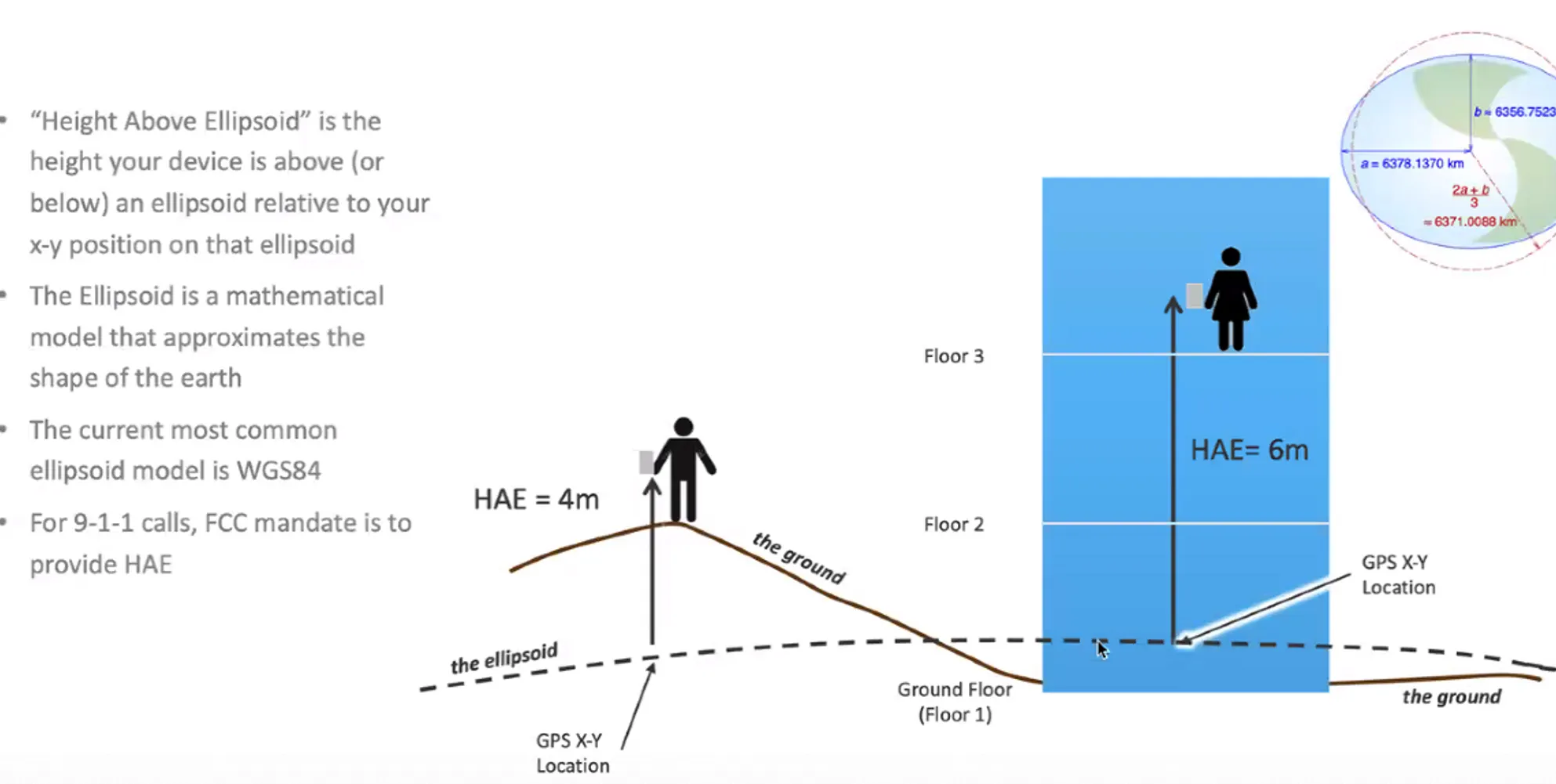
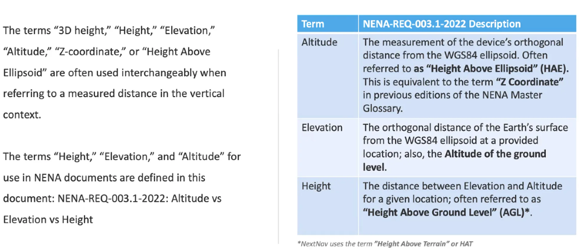
Height Above Ellipsoid (HAE) is the vertical distance above a mathematical model of the Earth’s surface (the ellipsoid), used as a reference for geodetic positioning.
Height Above Terrain (HAT) is the vertical distance from the ground or terrain level, which gives more practical information for responders when dealing with elevation in an emergency.
How Does the Underlying Technology Work?
Prepared’s Z-Axis feature uses barometric sensors already available in many mobile devices (phones, tablets, etc.) to calculate "height above terrain."
This data helps to deliver accurate, floor-level information to dispatchers and responders, ensuring the quickest and most accurate response to emergencies in multi-story structures.
What are the Input and Output Metrics?
Input: Location data from the caller's device (latitude, longitude, and elevation data).
Output: Vertical location information (height above terrain) displayed with an error margin.
Does NextNav Pinnacle Meet FCC Regulations?
As of June 2022, the FCC mandates wireless carriers to provide accurate "floor level" Z-axis data for E911 calls.
NextNav’s Pinnacle service exceeds these requirements, offering vertical location data accurate within 3 meters, 94% of the time, as verified by third-party testing.
Is it a 2D or 3D Representation?
Public Safety Answering Points (PSAPs) receive Z-axis information as Height Above Ellipsoid (HAE), which provides the height above a reference model of the Earth’s surface.
Currently, the system offers a 2D representation of the height. A 3D representation of buildings is in development, with a beta release scheduled for later this year.
Commonly Used Terms
Support & Additional Resources
For further assistance, contact us at Support@prepared911.com